Gateshead History Overview
Welcome to Gateshead History...Pre 1974? Prior to the Local Government Reorganisation of 1974, Gateshead was then Central Gateshead, including Low Fell, but did not include Dunston, Blaydon, Ryton, Felling, Birtley etc.
Most of the pictures on this web page are from Gateshead Council's fantastic photographic collection now available online at isee
Most of the pictures on this web page are from Gateshead Council's fantastic photographic collection now available online at isee
Was the place ever called Goatshead in it's early history?
The name of Goatshead seems to be connected with the Church. The Venerable Bede in the 700s described Gateshead under the Latin name of Ad Caprae Caput meaning Goat's Head. Just to confuse things, our word 'goat' comes from Old English 'gāt', which derives from Proto-Germanic 'gaitaz' (cf. Dutch/Icelandic geit, German Geiß, and Gothic gaits. Bede was a talented fella of his day, no doubt, but he got stuff wrong and/or made stuff up.
Per an abott called Utta in 653 A.D. the name derived from goats herding on the southern banks of the Tyne in Saxon times. See here for my best guess
Per John Sykes we have this ...1164. Hugh Pudsey, bishop of Durham, granted to the burgesses of Gateshead the liberty of their forest there, under certain restrictions. By this charter the bishop grants also to the burgesses, that each shall have, in right of his burgage, similar liberties to those enjoyed by the burgesses of Newcastle in right of their burgage.
1291. At what time the present church at Gateshead, dedicated to St. Mary, was built, cannot now be ascertained, but mention is made of it at this period. The shape and hewing of its stones prove that it has been built out of the ruins of some Roman edifice. In 1719, an old brass seal was dug up under a third pavement in Carlisle, with this inscription. " S" Beate Marie de Gatliesevid." The old church in which Bishop Walcher was murdered, stood farther to the east, in a field below the Rectory- house, formerly called Lawless Close, but afterwards the Miller's field.
1316 — Gateshead was governed by a bailiff, a patentee officer, under the bishops of Durham. The names of several persons who filled this office, occur as witnesses to charters in the vestry, from the above year, to 1620, when it was held by Sir Thomas Riddell, knt. The borough petitioned the bishop to appoint them a new one in 1772, setting forth, that since the death of Robert Delaval, whose patent was dated in 1681, that officer had been discontinued, and that they had still in their possession a seal inscribed " Sigil~ lum Burgh de Gateshead." The bishop referred the matter to his attorney-general, ...but as yet no bailiff has been appointed, said Sykes in 1833
1334 King Edward III., by a writ, forbade the mayor and bailiffs of
Newcastle, to hinder the mooring of ships on the south side of the river
Tyne.
1384 King Richard II. granted a charter to the bishop of Durham, for the mooring of ships, the loading and unloading of coals, &c., in the river Tyne, without molestation from the men of Newcastle. (The cheeky nowts)
1415 Langley, bishop of Durham, recovered by suit in the king's court, the third part of Tyne bridge, adjoining to Gateshead, from the mayor and burgesses of Newcastle, together with a tower, which that body had lately caused to be erected thereon. (Gateshead is 50% owner of current Tyne Bridge)
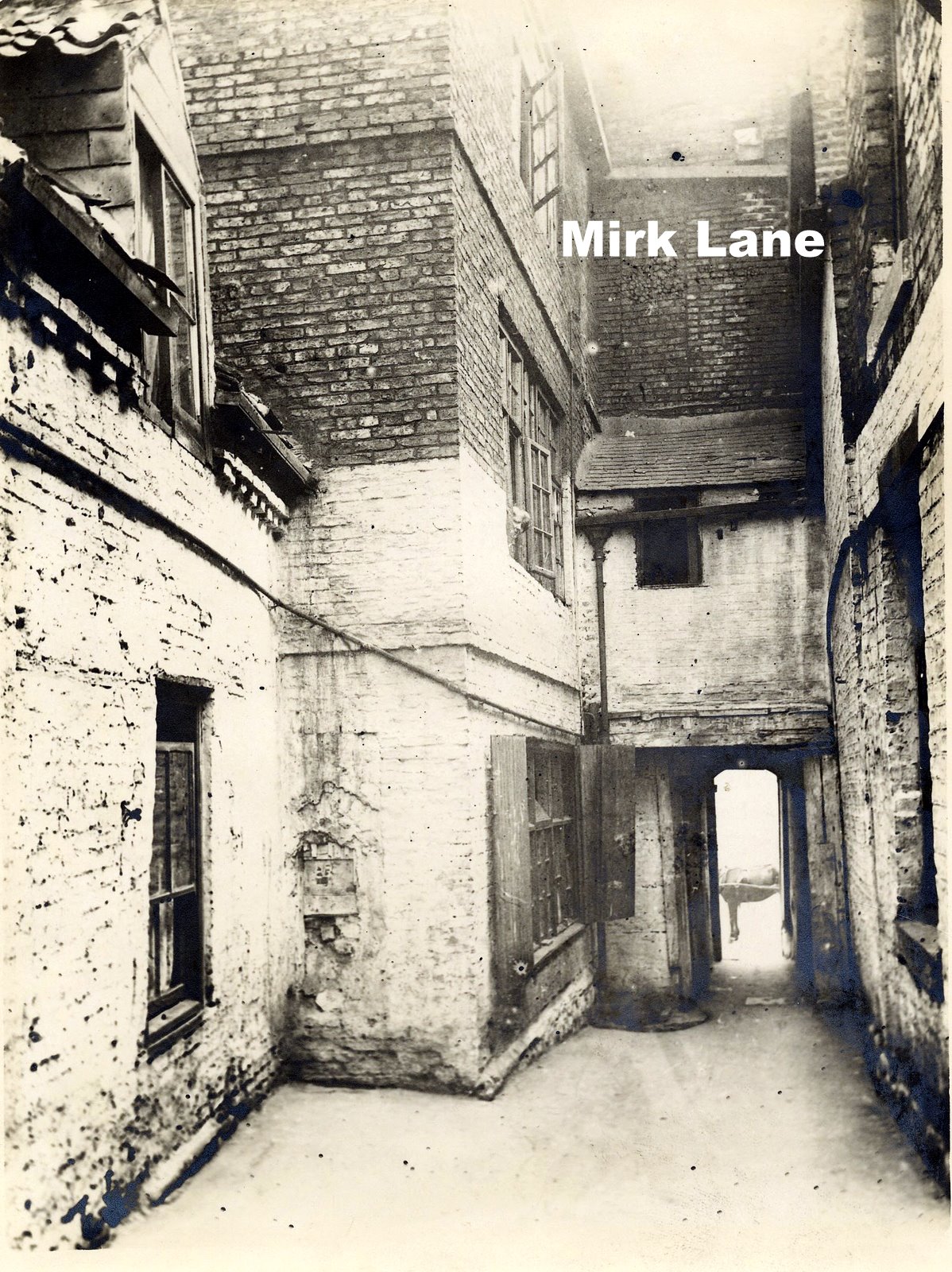
1553. The bishopric of Durham was dissolved, and Gateshead was annexed by act of parliament to Newcastle. King Edward VI. proposed to have erected a bishopric at Newcastle,(Nicholas Ridley, a native of Northumberland, was named to be the Newcastle bishop.) out of part of the dissolved see, but these purposes were defeated by his death, and on the accession of Queen Mary, the bishopric of Durham was restored. Gateshead was also in 1554 taken from Newcastle, and restored to the county of Durham.1577. Gateshead before it shrunk under the influence of Newcastle, had a borough market, which according to depositions taken this year, was held twice a-week (Tuesday and Friday), and extended from the market cross, betwixt the tollbooth and the pant, to the blue stone on Tyne bridge, or to the Brig-gate. The toll- booth stood in the main street nearly opposite to the west end of Oakwellgate. It had formerly been a school and latterly a place of confinement for disorderly persons. At this period also the pen- fold, afterwards removed to Windmill-hills, stood in the middle of the street opposite to the five wanned-mill. The post-road came down St. Mark's-lane (corrupted to Mirk-lane), and entered Gateshead by Half-moon-lane, or Miller's Chare.
1623 and 1636 and 1645 It is noted that the plague raged at Newcastle and Gateshead. The parish register of Whickham, contains frequently recurring traces of the plague having visited that place between the years 1610 and 1647. During these visitations, the people lived in lodges or huts upon Whickham fell and in Gateshead, the poor infected people were removed to huts erected on the common at Bensham.
1658 June 22 In one of the vestry books belonging to Gateshead church, is a copy of a letter dated Whitehall, as above, by which the twenty-four of Gateshead, because they were thought unfit to hold any public trust, and to have power of quelling profaneness and other crimes, was dissolved and a new one appointed in its stead, by his highness and council.
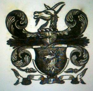
1666 This is a representation of the arms of the borough of Gateshead, taken from the back of an old chair in the vestry of St Mary's church.
The arms are in relief, and above them the letters L A. PB. I W. P T. being the initials of the names of Lancelot Ayer, Peter Bell, John Wolfe, and Peter Trumble, who were churchwardens in 1666, in which year this chair appears to have been made, as the following entry occurs in the parish books under this date " Paid for a new chaire and covering a stoole for ye vestry £1. 21696 Aug. 8 About six o'clock in the evening " a sad and lamentable fire" broke out in Gateshead, which suddenly burnt down and consumed the dwelling house of Henry Holmes. It also did great damage to the houses of Thomas Potts, widow Hutton, and several others, destroying many rich goods, wares, and household furniture, amounting to the value of one thousand two hundred and fifty five pounds. The judges of assize, Sir Edward Ward, knt., and Sir John Turton, knt., then upon the northern circuit, having, in passing down Gateshead, been eye witnesses of this calamitous visitation, recommended the case of the sufferers to the archbishop of York, the bishop of Durham, the bishop of Chester, and the bishop of Carlisle, who ordered collections to be made in the various churches of their dioceses for the relief of the sufferers.
1701 Jan. 9 The school, at the anchorage, in Gateshead church-yard, was founded by Theophilus Pickering, S. T. P., Rector of Gateshead.
1248
the hospital of St. Edmund the Confessor, and St. Cuthbert, in
Gateshead, was founded and endowed by Bishop Farnham. It was for a
master and three brethren. This building is supposed to occupy the site
of a monastery, which appears from Bede to have been established here
before the year 653.
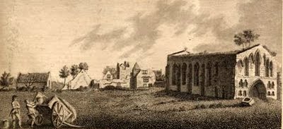
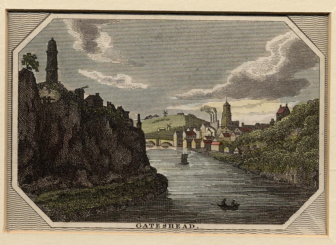
This picture is of St Edmund's Chapel (1784), part of Goatshead Monastry. The Monastry is clearly documented as being called Goatshead (But note other prints, it is said, show this to be called Gateside Monastry)Was the area, (there wasn't, then, a town) ever called Goatshead?
I can see the influence the Church would have had on an area totally administered by the Prince Bishops and, other than the monks in Goatshead Monastry, how many other people lived in this area to care what its name was.
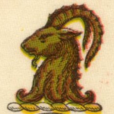
Clearly, the first secular adminstration perpetuated the goat in it's emblem but not in the name of the town.
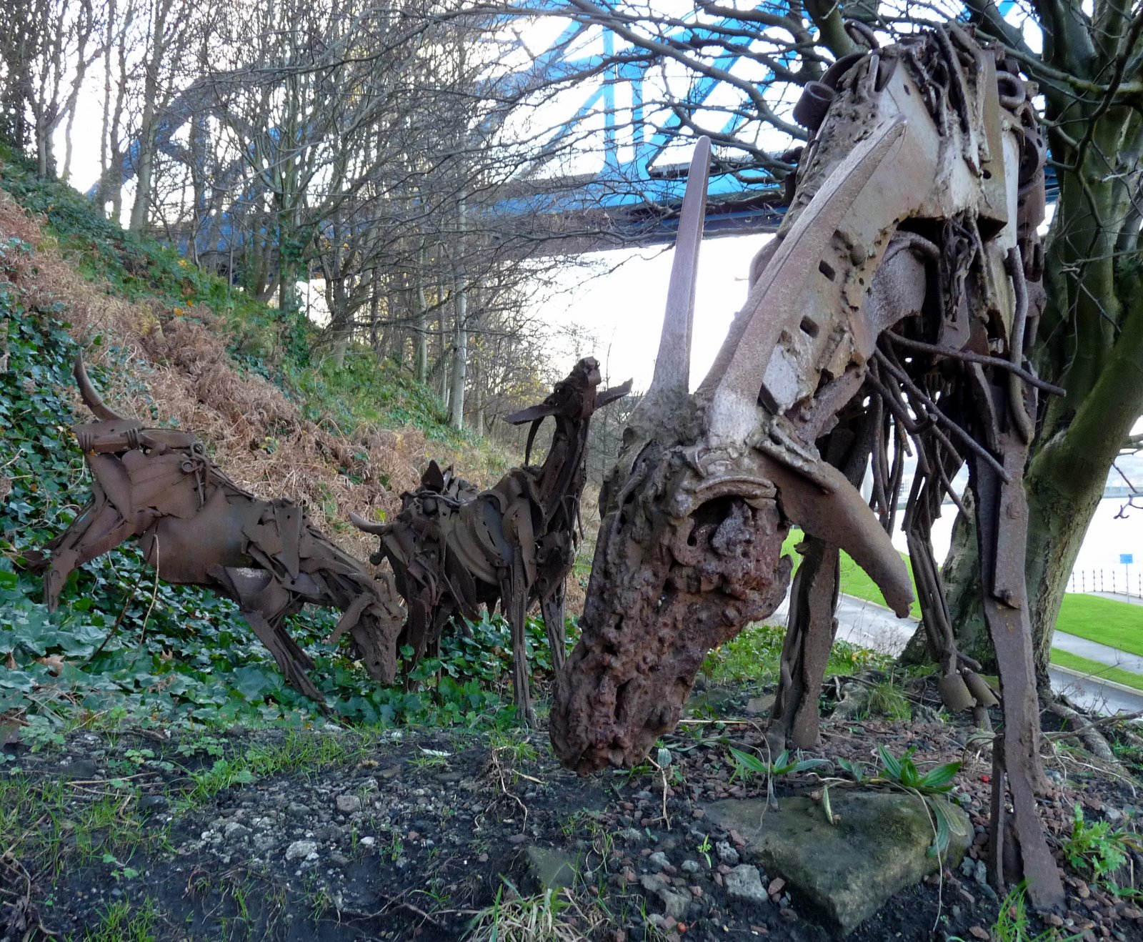
You'll be reading soon about Pipewellgate and Rabbit Banks which has been cleared and landscaped and several pieces of public art have been installed including this lovely understated installation
Left click to enlarge
...goats,
these ones industrial, once again grazing on the southern banks of the TyneThe name Gateshead is used in charters and surveys in the 12th Century, long before the first secular local authority.
"1066 And All That. When William of Normandy invaded England; there was no Gateshead; there was no Newcastle. There was a Roman bridge over the Tyne and a Roman fort where the Newcastle Keep now stands. And more important even than these structures: The Roman Wall, running from East to West, for which the bridge and fort were part of an integrated defensive system. The Roman fort would have a walled in section of the river to provide a protected landing in times of hostilities, where the Quay now is"
"...the New castle (1080) was built to overawe the populace. This New castle was built in timber at first. The head of the gate of that fortress was the South bank of the bridge that led to it; hence the name: ‘ Head of the gate, or, Gateshead........

Left click to enlarge
Bridges tells you more about all bridges over the Tyne
The object of the monopolists of Newcastle was to have the inhabitants of Gateshead restrayned or forbidden " to keep
any fayers or markets in Gatesyde, or openlye to sett to sayle any wares in Gatesyde, or to open or kepe any marchants shopp therein, or to sett for the any stalls or boothes with anye kind of wares to be solde there." Although we have no record of the decree in the suit, it is clear that the evidence of the witnesses was decidedly favourable to the Gatesiders.
No wonder the Church preferred the other name.
The word gate is also used for road or street as in Pipewellgate, Oakwellgate and Hillgate (The principal streets in early Gateshead) so the name Gateshead could mean the head of the road ie the road from the roman fort at Chester-le-Street to the roman fort at Newcastle. See next section which has a reference to the name Gateshead in 1539 but elsewhere it is said that the name Gateside was also used which, to me, strengthens the idea that the thrust of the name is Gate rather than Goat, and, to me, makes a lot more sense

Left click the image to see it enlarged
St Edmund's Chapel

Left click the image to see it enlarged
This was Holy Trinity Church, then Community Centre, and now renamed St
Edmund's Church on Gateshead High Street and the section on the right
is the original St. Edmund's Chapel.In 1836 the ground and building of the ruined chapel/hospital was given to the Rector and Churchwardens of Gateshead, with land for schools to be built. A public collection was made for the repair of the building and the restored Chapel (supervised by John Dobson) was opened as Holy Trinity in 1837.
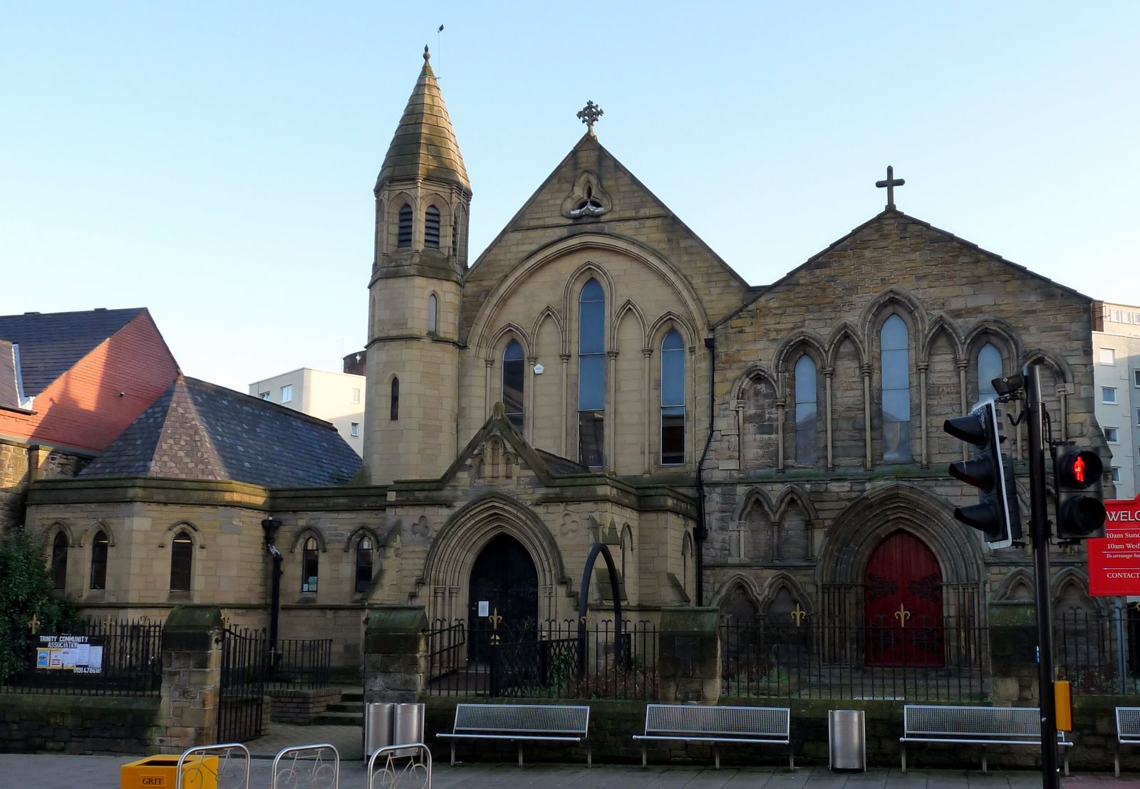
This gem is still there, in all its glory, on Gateshead High Street. If you haven't been, go there immediately...indeed you can borrow my bus pass to go and admire it
...there's precious little else to admire on the High Street
THE EARLY HISTORY OF GATESHEAD
The following is taken from this nice piece of work
" During the Middle Ages Gateshead is described as a place, rather than a vill (town) or a borough Real growth began with the establishment of Norman Bishops of Durham from 1072.

At this time in history the area now known as Gateshead was either forest or wasteland with some agricultural land. The forest, which covered much of East Gateshead, was used as a hunting reserve by the bishops of Durham who had a hunting lodge or manor house in the area.
GATESHEAD HISTORY MARCHES ON THRO' THE 12th TOWARDS THE 13th CENTURY
In the late twelfth century dyeing and shipbuilding are mentioned. At this time, Gateshead was paying a tax of £10 per year to the bishop of Durham, the highest sum for any Durham town. The appearance of Gateshead was changing, the first man-inspired changes in the town. The forests, which had probably covered the area for hundreds of years, were being cleared to make way for agriculture. Gateshead was growing steadily, if slowly. The first recorded market was held in l246, while a bailiff is mentioned in a document dated 1287. The bailiff was the representative of the bishop of Durham, the first such officer was Gilbert Gategang.

Left click to enlarge
1340s First coal mines opened
1408 A staith was built at Pipewellgate
GATESHEAD HISTORY REACHES THE 17th & 18th CENTURIES
1649 Three witches were arrested
1719 Daniel Defoe came north to avoid debts and lived in Hillgate..
...where, it is said, he wrote Robinson Crusoe

Left click the image to see it enlarged

This is Hillgate in 1930 before slum clearance
Freak rain in 1771 caused the river to rise and a significent section of the bridge was swept away, as shown in this print. Gateshead was cut off. (This lead to Gateshead's first Post Office being established). A temporary wooden structure was built and a ferry established while another bridge was built on the same site,
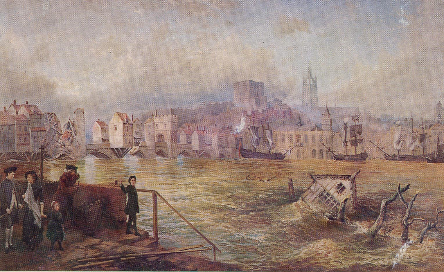
but it was not until 30 April 1781 that the new bridge with nine arches was opened.

Left click the images to see most of them enlarged
1819 Gas Works built in Pipewellgate. This is Pipewellgate in 1844 (print) and1910 (photo). It is a flattering photo. Here's a description of the place. "It was generally regarded as one of the worst residential areas in Gateshead. In 1850 Inspector R. Rawlinson wrote of Pipewellgate, 'Neither plan nor written description can adequately convey … the true state and condition of the room-tenements and of the inhabitants occupying them.
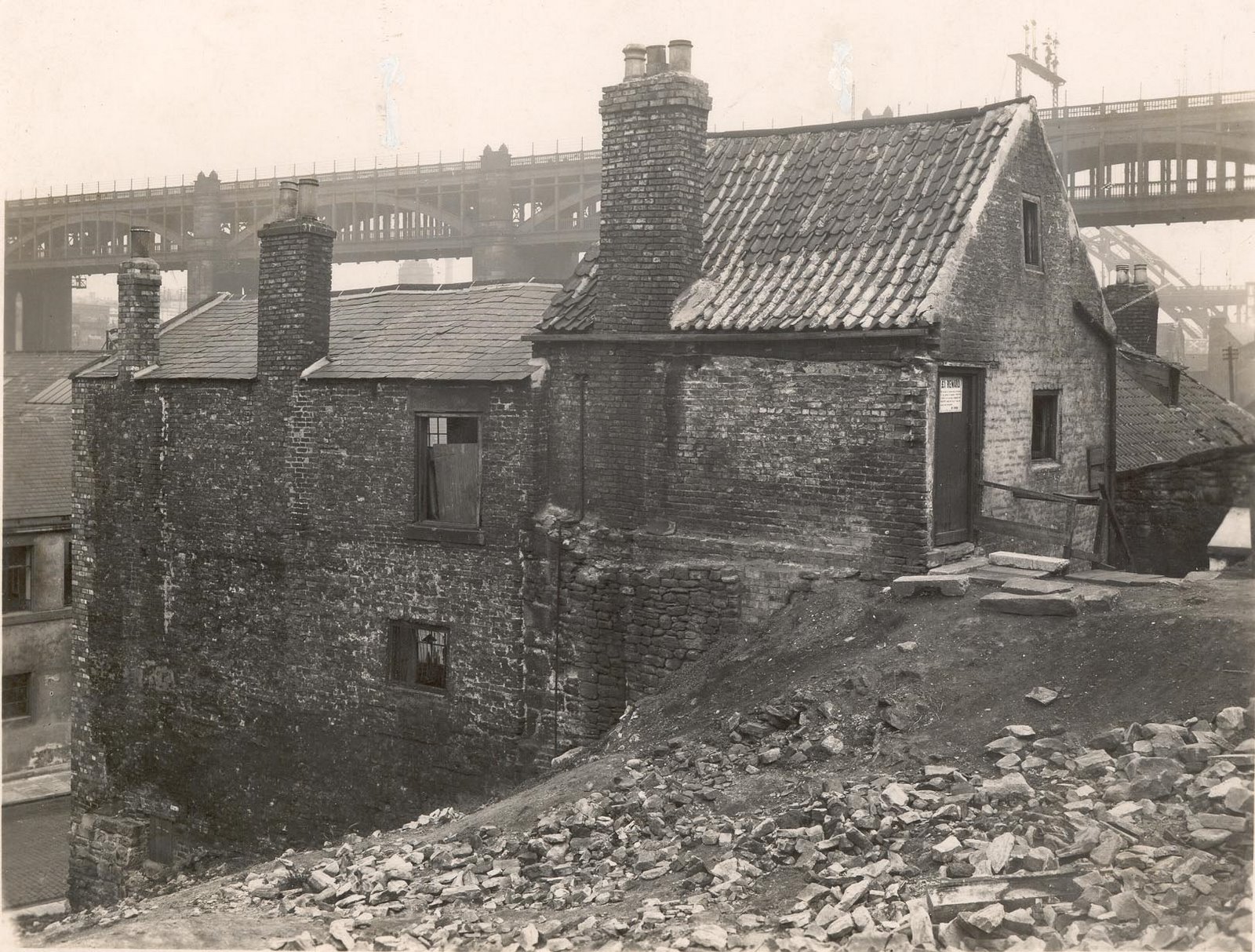
The subsoil on the sloping side of the hill is damp and most foul, the brickwork of the buildings is ruinous, the timber rotten; and an appearance of general decay pervades the whole district … Single rooms are let off as tenements which are crowded with men, women and children; the walls are discoloured with age, damp and rot; the windows are broken, old rags, straw and boards occupying the place of glass, so that means of light and ventilation alike are absent".
Pipewellgate (both sides west of High Level Bridge), Rabbit Banks Road, High Level Road, Wellington Street (west side of), Hudson Street, Half Moon Lane (portion opposite Coal Depots), Bruce's Buildings, Pipewellgate Banks, Chapel Yard Chatham, Harrison's Buildings, Procter's Buildings, Providence Place, Scotts Buildings, Scotts Row, Scott's Cottages, Veitch's Buildings,
Left click the image to see it enlarged
Bowl Alley Bank (see above),
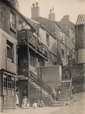
Blacksmiths Bank, Brown & Thistle Yard, Marlins Yard, Pipewellgate Road, Askew Road (no houses)Proktors Buildings, Scott's Row, Veitch's Buildings, Bowl Alley Banks and Scott's Buildings previously mentioned, were rows of tenements built on the hill between Pipewellgate and High Level Road. The houses on each were linked by external staircases, either wooden or stone flagsones, and each "landing" had a cold water tap and an earth or ash closet.
Bankwell Stairs reached from Bankwell Lane
This picture is copyright Durham County Council. Your use of the image is restricted to personal use only, and you must not copy, publish or distribute the image in any way
Left click on this 1920 photo to see Bridge Street leading up to Church Street and Bottle Bank
Here's another view showing the beginnings of the Tyne Bridge. Bridges tells you more about all bridges over the Tyne

Top of Church Street where it joins the foot of the High Street
Church Walk, which had a nice view of the church out of the front windows and a lovely view of the river and Newcastle out of the back windows, though how those back windows were cleaned goodness only knows. If you visit St Mary's Church take a walk along the path
with the church wall on your right and the steep drop into the Tyne on your left and be staggered at how they managed to perch these houses on the precipice
Oakwellgate...this in the Town Hall and later, part of it became Bush Inn
This is Oakwellgate Baths built in 1855.
Cannon Street
Brandling Street
VICTORIAN HISTORY IN GATESHEAD
Industrialisation brought about a staggering increase in Gateshead's population. To backtrack slightly, there was only gradual change in the 200 years of history from the beginning of the 1600s (approx 3,000) until the end of the 1700s when the figure stood at 7500
Left click the image to see the 16th century tyne bridge in detail
Left click
100 years later in 1901 the figure had risen to 110,000. That's almost a 15 fold increase. Indeed, until 1974 when Local Government Reorganisation greatly increased Gateshead's boundaries, the population had virtually peaked at the end of the 19th Century (but for small increases in the 1920s/1930s) Gateshead really came of age in the 1800s and the rate of change was staggering. There was massive growth in industry, house building, and town spread southwards, but matching growth, in disease, drunkeness and deprivation. If the lane to Newcastle was dirty in the 1700s it was to get a lot dirtier, certainly in the first few decades of the 1800s, after which it started to improve, with lots of new houses being built from the 1860s onwards. It could have continued getting better and better but for 1960s architecture, screwing it all up again
As late as 1681 the town was governed by the bishops of Durham, since which time the government was vested in two stewards, who possesd no municipal authority or jurisdiction, and who were elected annually by the borough-holders and freemen. Prior to 1833 it was merely a borough by prescription, there being no charter extant, though it is believed to have been once incorporated. By the Reform Act it became a parliamentary borough, and returned one member to parliament.
GATESHEAD HISTORY IN THE 19th CENTURY
In 1835 the town became a Municipal Borough in which three aldermen and eighteen councillors took over local management. In 1837 the town's first newspaper, the 'Gateshead Observer' was published. In 1838 a police force was established. There were two 'lock-ups', one in the Town Hall-, the other at the Bridge End. A constable was paid seventeen shillings (85p) per week, for an eleven hour day, and got one free suit and two pairs of shoes per year. 1855-57/58) The Police force was increased to twenty two men and got its first Sergeant and first Chief Constable
In 1874, the pubs in Pipewellgate were the Blue Bell, the Brandling Junction, the Cross Keys, the Crown & Thistle, the Fountain,
Globe Inn, (left click)
The gentleman standing outside of the Globe Inn in 1912 is William Lockie, landlord. The sign above the door reads: Globe Inn, William Lockie, Licensed to retail, Ale porter and tobacco. Hendersons Alloa Ale is advertised on the windows, a pint costing tuppence and a half pint costing a penny
It is reported that Lockie would hose down the cellar walls to wash off black beetles and a truncheon was kept behind the bar to help deal with any unruly seaman.
The McGurks were Beer Retailers from the Globe Inn in 1890 and John McGurk deceased from there
New Bridge Inn
and the Three Tuns
Left click on the images to see them enlarged
This is Pipewellgate, the last remnants of which was finally demolished in early 1930s
Rabbit Banks was landscaped in 1969.
If you go back aways to the modern map and choose the bird's eye view you can see that the landscaping now looks like a veritable forest.
Bretts Oils was previously the site of Joseph Price's Glass Works
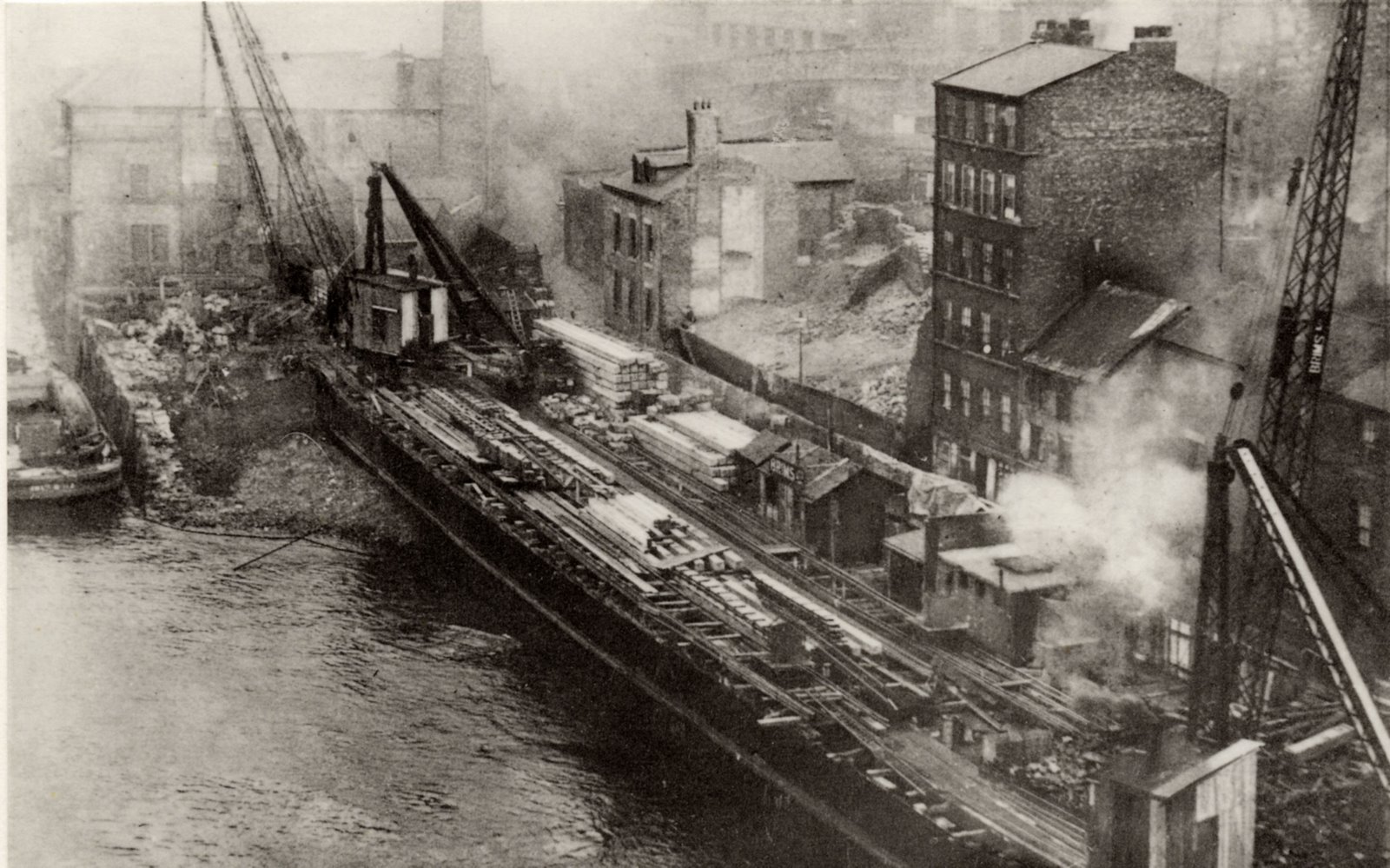
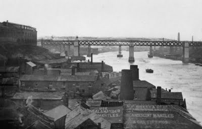
This is where Pipewellgate meets Bridge Street. You can see the once very ugly but now landscaped and art infested Rabbit Banks in the distance. It's now a lovely but totally ignored bit of Gateshead. Go now and admire it
In 1838 there were two principal streets ; the old Durham Road descending towards the bridge was so steep as to be almost impassable for carriages during winter; the other, the new Durham Road, of recent erection, was of gradual descent. The church is an ancient and spacious edifice, built in the form of a cross, surmounted by a lofty tower. There were two living areas ; the rectory of Gateshead and that of Gateshead Fell. There were several charitable institutions, among which is an almshouse for poor women. The town was said to be thriving and increasing annually in manufacturing and commercial importance. It possessed coal mines, extensively worked, situated within the borough, and which employed a considerable portion of the population of the town. The chief manufactories were of glass, cast and wrought iron, and whitening ; and at Gateshead-fell there was an extensive quarry for grindstones
THE COMING OF THE HIGH LEVEL BRIDGE & THE RAILWAYS, AN IMPORTANT POINT IN GATESHEAD HISTORY
The New Bridge Inn in Pipewellgate.. Presumably this was built about the same time as The Bridge, the highly successful pub on the Newcastle side of the High Level Bridge, both being built and /or named because of the High Level Bridge which would have caused quite a stir
1849 Opening of High Level Bridge took traffic away from old Town Bridge and thus from Pipewellgate area.The 1781 bridge was demolished in 1868, prior to...
1876 The Swing Bridge opened. Bridges tells you more about all bridges over the Tyne
1880 38 bed isolation hospital established, which, ultimately, became the Queen Elizabeth Hospital, opened 18 March 1948 1906 Opening of King Edward VII rail bridge
1928 Opening of the Tyne Bridge Bridges tells you more about all bridges over the Tyne
1932 - 1936 Slum clearance orders leading to clearing of Pipewellgate and rehousing in Carr Hill, Sheriff Hill and Old Fold areas. 1969 Landscaping of Pipewellgate and Rabbit Banks
1854 The Great Fire of Newcastle and Gateshead, which devastated Newcastle Quayside and Gateshead Hillgate, left Pipewellgate virtually unscathed. Click the link to read all about it
In 1831 The Cholera Plague swept the town and the population was reduced by about half. The Rector of Gateshead and William Henry Brockett established this Dispensary in West Street.
1849 Cholera epidemic
During the month of September 1849 the cholera attained its greatest virulence in the district, and its ravages excited intense alarm.
Nearly one-third of the population of the villages of Lamesley,
Wreckington, and Ayton Banks, near Gateshead, were affected
with the disease, and more than one-half of the cases terminated
fatally. At North Shields 137 were reported in a single week,
and the total mortality in the Tynemouth and South Shields
Unions was no less than 1,174 ; in Sunderland the deaths
amounted to 435 ; Newcastle, 414 ; Gateshead, 292 ; Durham,
232 ; Barnard Castle, 146 ; Alnwick, 142 ; Berwick, 49 ; and
Hartlepool, 161. The total number of deaths from cholera
during the year in the two counties were : Durham, 2,022 ;
Northumberland, 1,680.
1853 Cholera epidemic
At Gateshead the mortality was 433 ; the township of Heworth, 98 ; Whickham, 21 ; Winlaton, 14.
Behind the main streets were alleys and courts with poor drainage and no sanitation. The living conditions were poor but not as bad as the overcrowding later in the century when there was a plague of cholera, typhoid and smallpox.
This is currently a Bank (left) and defunct Post Office (right)
The building on the right is built on the spot that Thomas Bewick's house stood...
....Thomas Bewick's actual house, which shamefully was demolished. Bewick (1753-1828), the wood engraver, lived at 19 West Street, Gateshead, from 1812.
They must have realised his place in history because they named Bewick Road after him..so surely the building could have been retained. It looks in canny nick in this photo.
On the east of High Street were houses with courts, alleys and streets behind continued almost as far as Jackson's Chare (Jackson Street), but on the west there were gardens and an orchard on the site of what is now the shopping precinct and multistory car park. Barnes Close was fields and Bailey Chare, later called Half Moon Lane and now Mulgrave Terrace, was a country road leading from High
Street to the Windmill Hills giving the traveller a fine view of the Tyne Valley. There were some houses on West Street and a windmill at its junction with Jackson's Chare where the Co-operative Store stands today.