History of Wrekenton

Welcome to the History of Wrekenton which brings you a flavour of life in Wrekenton in the past
Inspired by this excellent website
Wrekenton
I decided to relaunch my History of Wrekenton which hitherto was just an adjunct to the History of Low Fell
You may find it helpful to click on this link
Map
Then select historical maps and you can choose the time period and the scale. You will see later some pics of the maps I looked at
Wrekenton is the "town or village near the Roman causeway" - the Wrekendyke which most folk know nowadays as Leam Lane that runs in a straight line (naturally) east from the Springwell Inn all the way to South Shields but it also ran west to Lamesley and beyond. The antiquarian, the Rev. John Hodgson, claimed to have named the village. He wrote, " After the enclosure of the common, in 1822, Mr Watson, of Carrhill, founded a considerable village at this place, which, at my suggestion, he called Wrekenton."

This name was chosen because Wrekenton and Eighton Banks were divided by the remains of a Roman Road called Wrekendyke, which formed the southern boundary of Gateshead Fell parish. You can see that on the map..left click on it to enlarge
There used to be this pub, The Wrekendyke, on the Springwell Estate named after the old roman road
Landscape
The journey from Chester-le-Street to Gateshead in the sixteenth century was described as '... seven miles by mountainious ground, with pasture, heath, moor and firres ...'. The Division of Gateshead Fell following an Act of 1809 led to the development of what had been 'a wild, spongy, dark moor'.
The Fell was a wild and lawless place. The most reported highway robbery was that by Robert Hazlitt who robbed the mails in 1770. He was caught, hanged, and his body displayed on a gibbet at Beacon Lough.
Wrekenton was noted for its 'hirings', and a statute fair which brought in visitors from surrounding villages. From 1822, a hiring for farm and domestic servants took place on the second Monday in April and the first Monday in November. Booths extended from

Left click to see it today
the 'Ship'

Left click to see it today
to the 'Seven Stars', with roundabouts, sideshows, and races. Men and women stood in a row to be hired, and spent their 'arles' or 'hiring money' freely at the fair.
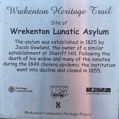
The Asylum
Wrekenton Asylum was controlled by a Mrs Gowland and Mr John Gowland (possibly her son). Although there was a farm attached where "those patients who are sufficiently well to go at large can receive healthy exercise and recreation", the crowding together in one building of the 37 patients led in 1849 to 20 deaths from cholera.

Left click to see it bigger
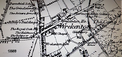
The Asylum's location is shown on this map as is, prominently, Cherrytree Hall, whatever that was
Here's a picture of The Asylum on the Wrekenton Community Heritage Project website
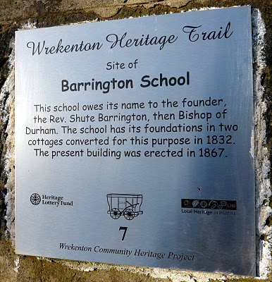
To the right of the Asylum, on the above map can be seen St Thomas' Church and opposite that on Galloping Green Road is shown what was then described in the plural as the Barrington Schools (Boys and Girls)

Left click to see it bigger
(It is now Brydon's Animal Sanctuary)
Memories of Alan Bull, a pupil at the school
Then there's this

This was the site of a Methodist New Connexions Chapel which became a picture house. A nice new Funeral Services building stands there now on Wrekenton Row
The following is by Margaret Galloway describing Wrekenton as it was from 1906 onwards
"Wrekenton was just one long road stretching from West View [North] to
Jubilee Avenue chapel [South]
with offshoots of roads along the way.

Left click to enlarge
The Mechanics Institute and “clock” was the centrepiece of Wrekenton and stood where the garage is now [now a Frozen Food shop].

Left click to enlarge
It was eventually to become the tram terminus for Gateshead and Newcastle.
Looking down the High Street facing north [on the left] was the

Left click to enlarge
Coach and Horses,
[One of the stopping places for the mail coach was the 'Coach and Horses', an inn known as Red Robin's. The landlord, Robin Rogerson, displayed a sign which read:
"Red Robin lives here,
Sells good wine and beer;
Pass ye East, or pass ye West,
If ye pass here ye pass the best."]
a large house where Blenkinson lived, Wilfred Smith’s drapery and Grocery shop, where the present paper shop is…….
Back to the Mechanics Institute, on the right hand side facing north was
Left click to enlarge
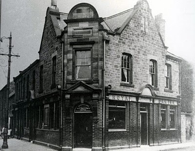
the Royal Oak which still stands,
[The rear of the Royal Oak was The Mill Yard where previously the old mill had stood. ]
a chemist and some front doors from Mill yard, the Blacksmith’s smithy came next where we would go to see the horses being shod.
Old Bob Dobson was the Blacksmith. There was a Blacksmith’s yard, a few houses and then Lowery’s yard, Jefferson’s yard, Stormont Main club, Maria Atkinson’s Bakery shop,

Left click to enlarge
the infant’s school,

Left click to enlarge
Birtley Co-operative store,
more houses,

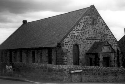
St.Oswald’s church and school,
more yards and houses,

the Seven Stars pub,
two streets called Boundary houses and

the Princess Alice Pub at the end.

Across the railway was

West View which remains….."
She didn't mention the National School, opposite to the Infants School [now the Community Centre] perhaps because it had already been pulled down. This plaque is on the wall next to the vacant plot where the foundations of the National School can still be seen. It suffered from mining subsidence and perhaps that's why it still remains vacant. Mind you, it could do with being tidied up
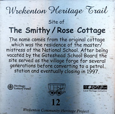

Originally Rose Cottage, the house of the head of the National School which became Dobson's Smithy and then Dobson's petrol station and now another untidy vacant plot

Left click to enlarge
Let's finish with the pubs. On the opposite corner of Springwell Road to the Royal Oak stood the Half Moon, gone now but in its place is The Clock
This map, left click to enlarge, also shows there was once a Joiner's Arms on the High Street. Oh and there's the Quarrymans or does this join the other, but now only Ship, the Waggon and the Lampton Arms as being in Eighton Banks?
I thoroughly recommend that you take a trip to Wrekenton (you may borrow my bus pass to do so) and follow the Heritage Trail. You might see me there again as I only found 4 plaques out of 12. Click the link if you want more Wrekkie Piccies
Well, that's it except for this

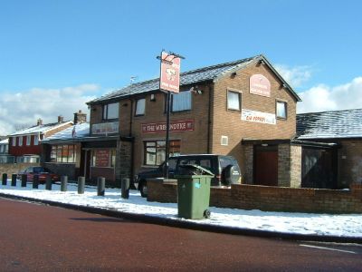
Hasn't this Car Repair Facility, Auto Care just got the biggest TV aerial? I don't know what this edifice is...a radio mast perhaps...hopefully this will not just be seen as a cheap device to promote Harry and Johnny's excellent car repair and MOT business. Pop in and see either of them two or Paul or Steve.